June 12, 2006
Basic
Facts about Meteorology
By
Dr. Frank J. Collazo
Introduction:
The blanket of air around the
earth is called the atmosphere. All our
weather happens in the bottom layer of the atmosphere called the troposphere,
which is six to ten miles thick. Meteorology is
the study of the changes in temperature, air pressure, moisture, and wind
direction in the troposphere.
The Sun Starts it All:
There is one basic reason we
have weather, and that is the sun.
Weather systems start because the sun's energy heats up some parts of Earth
more than others. Most of the time the sun shines most directly on the
middle of Earth, with less heating at the north and south poles. Earth is
tilted on its axis at exactly the right angle to have seasons, with different parts of Earth
being heated more or less during different times of the year. Land heats
up faster than water, setting up temperature differences between oceans and
continents. This unequal heating creates variations in temperature and
air pressure, winds, and ocean currents.
Air Masses and Fronts:
The winds move heat from the
tropical regions toward the poles in a never-ending effort to reach a
temperature balance. In the process, fronts set up between warm and cold
air masses and a stream of fast-moving air high up in the sky called the
"jet stream" forms. Disturbances develop along the fronts and
in the jet stream that trigger centers of low and high air pressure. The
fronts and low pressure areas make air rise to form clouds and precipitation.
Earth's Amazing Water:
Earth is also unique in that
all three forms of water--liquid, solid and gas--exist naturally. Heating
from the sun helps evaporate water from the oceans as a source for clouds and
precipitation. The sun-powered circulations of evaporation, condensation and precipitation
move Earth's water from the oceans to the atmosphere to land and back between
these three forms.
What else does the Sun do?
Heating from the sun can also
trigger thunderstorms.
Clusters of thunderstorms over warm ocean waters can turn into hurricanes. The sun is behind all
the changes in our weather, and if the sun were to suddenly go out, our weather
machine would stop too.
Precipitation:
In cold air way up in the
sky, rain clouds will often form. Rising warm air carries water vapor
high into the sky where it cools, forming water droplets around tiny bits of dust
in the air. Some vapor freezes into tiny ice crystals, which attract
cooled water drops. The drops freeze to the ice crystals, forming larger
crystals we call snowflakes.
When the snowflakes become heavy, they fall. When the snowflakes meet
warmer air on the way down, they melt into raindrops. In tropical climates, cloud droplets combine
together around dust or sea salt particles. They bang together and grow
in size until they're heavy enough to fall.
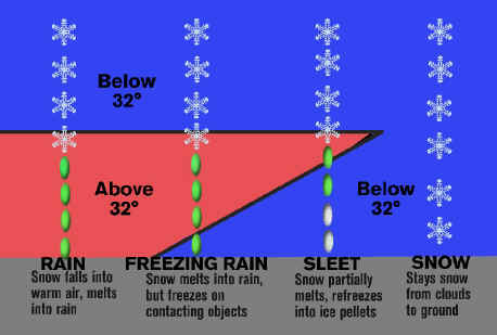
Look at the figure
above. Sometimes there is a layer of
air in the clouds that is above freezing, or 32 degrees F. Then closer to
the ground the air temperature is once again below freezing. Snowflakes partially melt in the layer of
warmer air, but then freeze again in the cold air near the ground. This kind of precipitation is called sleet.
It bounces when it hits the ground.
If snowflakes completely melt
in the warmer air, but temperatures are below freezing near the ground, rain
may freeze on contact with the ground or the streets. This is called freezing rain, and a significant
freezing rain is called an ice storm.
Ice storms are extremely dangerous because the layer of ice on the
streets can cause traffic accidents. Ice can also build up on tree
branches and power lines, causing them to break and our lights to go out. There is another kind of precipitation that
comes from thunderstorms called hail.
Thunder and Lighting:
Have you ever seen tall, dark
puffy clouds forming on a hot humid afternoon? These are called cumulonimbus clouds, sometimes nicknamed
"thunderheads." They can actually form any time of day when the
temperature falls rapidly higher up in the sky. These tall dark clouds
are full of moisture and contain strong up and down air currents. Cumulonimbus clouds may tower more than
50,000 feet, and cover from just a few square miles up to two hundred square
miles.
What is Lightning?
To put it simply, lightning is
electricity. It forms in the strong up-and-down air currents inside tall
dark cumulonimbus clouds as water droplets, hail, and ice crystals collide with
one another. Scientists believe that these collisions build up charges of
electricity in a cloud. The positive and negative electrical charges in
the cloud separate from one another, the negative charges dropping to the lower
part of the cloud and the positive charges staying ins the middle and upper
parts. Positive electrical charges also
build upon the ground below. When the difference in the charges becomes
large enough, a flow of electricity moves from the cloud down to the ground or
from one part of the cloud to another, or from one cloud to another
cloud.
In typical lightning these are
down-flowing negative charges, and when the positive charges on the ground leap
upward to meet them, the jagged downward path of the negative charges suddenly
lights up with a brilliant flash of light. Because of this, our eyes fool
us into thinking that the lightning bolt shoots down from the cloud, when in
fact the lightning travels up from the ground. In some cases, positive charges
come to the ground from severe thunderstorms or from the anvil at the very top
of a thunderstorm cloud. The whole process takes less than a millionth of a second.
Kinds of Lightning:
There are words to describe
different kinds of lightning. Here are
some of them:
In-Cloud Lightning: The most common type, it
travels between positive and negative charge centers within the thunderstorm.
Cloud-to-Ground Lightning: This is lightning that reaches from a thunderstorm cloud to the
ground.
Cloud-to-Cloud Lightning: A rare event, it is lightning that travels from one cloud to
another.
Sheet Lightning: This is lightning within a
cloud that lights up the cloud like a sheet of light.
Ribbon Lightning: This is when a cloud-to-ground flash is blown sideways by the
wind, making it appear as two identical bolts side by side.
Bead Lightning: Also called "chain lightning,"
this is when the lightning bolt appears to be broken into fragments because of
varying brightness or because parts of the bolt are covered by clouds.
Ball Lightning: Rarely seen, this is lightning in the form of a grapefruit-sized
ball, which lasts only a few seconds.
Bolt from the blue: A lightning bolt from a distant
thunderstorm, seeming to come out of the clear blue sky, but really from the
top or edge of a thunderstorm a few miles away.
What Puts the Thunder in the
Thunderstorm?
Lightning bolts are extremely
hot, with temperatures of 30,000 to 50,000 degrees F. That's hotter than the surface of the sun! When the bolt
suddenly heats the air around it to such an extreme, the air instantly expands,
sending out a vibration or shock wave we hear as an explosion of sound. This is
thunder. If you are near the stroke of
lightning you’ll hear thunder as one sharp crack. When lightning is far away,
thunder sounds more like a low rumble as the sound waves reflect and echo off
hillsides, buildings and trees.
Depending on wind direction and temperature, you may hear thunder for up
to fifteen or twenty miles.
Clouds:
You have only to look up into
the sky to try your luck at weather forecasting. Clouds give us a clue about what is going on in our atmosphere
and how the weather might change in the hours or even days to come. Each type of cloud forms in a different way,
and each brings its own kind of weather.
Cool Condensation:
Clouds are water. As you probably know, we can find water in
three forms: liquid, solid and gas.
Water as a gas is called water vapor.
Clouds form when water vapor turns back into liquid water droplets. That is called condensation. It happens in one of two ways: when the air
cools enough, or when enough water vapor is added to the air. You’ve seen the first process happen on a
summer day as drops of water gather on the outside of a glass of ice tea. That’s because the cold glass cools the air
near it, causing the water vapor in the air to condense into liquid. Unlike the drops on the side of your glass
though, the droplets of water in a cloud are so small that it takes about one
million of them to form a single raindrop.
Most clouds form this way, but the cooling comes not from ice in a
glass, but as the air rises and cools high in the sky. Each tiny cloud droplet is light enough to
float in the air, just as a little cloud floats out from your breath on a cold
day.
Too Clean for Clouds?
Our air has to be just a
little bit dirty for clouds to form.
That’s because water vapor needs a surface on which to condense. Fortunately, even the cleanest air has some
microscopic particles of dust, smoke or salt for water droplets to cling to, so
the air is rarely too clean for clouds to form.
Cloud Classifications:
Meteorologists name clouds by
how high in the sky they form and by their appearance. Most clouds have two parts to their
name. Usually the first part of the
name has to do with the height and the second part refers to the appearance.
If clouds form at the highest levels, they get the prefix “cirro” as the
first part of their name. Middle clouds
get the prefix “alto.” Low clouds don’t
get a prefix.
There are two cloud
appearance types: cumulus and stratus, which are also the basic names of the
low clouds. Sometimes they appear
higher in the atmosphere and get a combination name with a prefix. For example, middle cumulus clouds are
called “altocumulus” and high stratus clouds are “cirrostratus.” If a cloud produces rain or snow it gets
either “nimbo” at the beginning or “nimbus” at the end.
Cumulus clouds are low
individual billowy globs that are low, have flat bases and look a little like
cauliflower. They are at least as tall
as they are wide and form on sunny days from pockets of rising air. Their constantly changing outlines are fun
to watch because they can take the shapes of almost anything, including animals
and faces. Cumulus clouds usually
signal fair weather. If they build into the middle or high part of the
atmosphere they get the name cumulonimbus.
A cumulonimbus cloud is tall, deep and dark and can bring lightning,
heavy rain and even severe weather such as hail, damaging winds or
tornadoes. It is a sign of rapidly
rising and sinking air currents.
Stratus clouds are layered
and cover most of the sky. They are
much wider than they are tall. If you
see them in broken or puffy layers, they are stratocumulus clouds. If you
see them in thin high layers that turn the sky solid white, they're
cirrostratus clouds. The tiny prisms of
ice in a cirrostratus layer can bend the sun's light. As a result, often
you can see a halo or veil of rainbow colors around the sun. When stratus clouds are very thick, they
become dark nimbostratus clouds, which can produce rain, drizzle or snow.
Cirrus clouds are high and
thin and made entirely of ice crystals.
Forming above 20,000 feet in the atmosphere, they often look like wisps
of white hair. Cirrus clouds, which are
a sign of warm moist air rising up over cold air, are sometimes an early signal
that thickening clouds could bring light rain or snow within one or two
days. Try to learn the names of the
different clouds, and the next time you look up into the sky, take notice of
what kind of clouds you see. And if you
try, you might be able to guess what kind of weather they will bring.
Snow:
Snowflakes form when water
vapor freezes into ice crystals in cold clouds. The ice crystals attract
cooled water droplets to form various shapes. They get heavy and
fall. If the air is cold enough, the snow falls all the way to the earth
without melting. If the ground is freezing, the snowflakes stick to the
ground.
No Two Alike?
Have you noticed that there are many
different shapes of snowflakes? That is because a snowflake is usually
made of many different kinds of snow crystals, and the shape of a snow crystal
depends a lot on the temperature at which it forms. Table I illustrates
the shape of the crystals corresponding to temperature:
Table I Temperature/Snow Flakes
Relationship
|
Temperature Range |
Crystals Shape |
|
25-32 degrees F |
Thin Plates |
|
20-25 degrees F |
Needles |
|
15-20 degrees F |
Hollow columns |
Usually the colder the temperature, the smaller the crystals. As the crystals fall from the cold clouds, they bump into other crystals and freeze together, making even more shapes. This is one reason why it's so hard to have two snowflakes exactly alike. In fact, in air right at the freezing mark, several snowflakes may stick together, forming large clumps of flakes that may melt as they hit the ground.
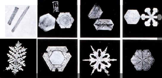
Snow photographs by Wilson A. Bentley
("Snowflake Bentley") of Jericho, VT
Snow is one kind of weather
that people can duplicate.
The Sun:
The sun causes all our
weather because it heats the earth unevenly.
The contrast between the hot parts and the cold parts of the earth turns
our atmosphere into a powerful engine. The engine keeps cold and warm air
moving and makes changes in air pressure.
Those air pressure changes cause wind. The heat of the sun also helps
moisture to rise and form clouds,
bringing rain, snow, or thunderstorms. So all the changes in
our weather come, at least indirectly from the sun.
Blanket of Air:
As the sun warms up the earth, the ground absorbs the heat, and
reflects some of it back into the air. That's one reason why it's usually
warmer near the ground and cooler on the higher hills and mountains. The
atmosphere acts like a big blanket over the earth, holding in the warmth and
reflecting it back to earth.
Air Pressure:
The wind blows because air
has weight. Cold air weighs more than warm air, so the pressure of cold
air is greater. When the sun warms the air, the air expands, gets
lighter, and rises. Cooler, heavier air blows to where the warmer and
lighter air was, or in other words, wind usually blows from areas of high air
pressure to areas of low pressure. If the high pressure area is very close to
the low pressure area, or if the pressure difference (or temperature
difference) is very great, the wind can blow very fast.
High or Low:
Although wind blows from
areas of high pressure to areas of low pressure, it doesn't blow in a straight
line. That's because the earth is rotating. In the northern
hemisphere, the spin of the earth causes winds to curve to the right.
This is called the coriolis force. So in the
northern hemisphere, winds blow clockwise around an area of high pressure
and counter-clockwise around low pressure.
See Note 1.
How Fast Is It?
You can estimate wind speed
with the Beaufort Scale. It was developed in 1805 by a Navy admiral to
measure wind at sea. But we can also use it to measure wind on land.
Miles Per Hour Effects:
<1 Smoke rises straight up, no motion
1-3 Smoke drifts slowly, tree leaves barely move
4-7 Leaves rustle, wind felt on face
8-12 Leaves and twigs move,
dust raised from ground
13-18 Small branches move,
dust and paper blown away.
19-24 Small trees and large branches sway
25-31 Big branches move a lot, wind whistles, umbrellas
turn inside out.
32-38 Whole trees sway, hard to walk
39-46 Tree twigs break, very hard to walk
47-54 Branches, roof tiles blown down
55-63 Trees uprooted, severe building damage
64-72 Widespread building damage
73+ Severe destruction
Wind Pump:
Use a bicycle pump to show how air
pressure makes wind. When you push down on the pump, the air pressure
inside the pump is greater than the air pressure outside the pump. So the
air flows from the high pressure inside the pump to the lower pressure
outside. The harder you pump or the greater the difference in air
pressure, the faster the air blows out.
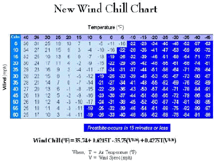
How Cold Do You Feel?
Wind makes you feel cooler,
because it causes your body to lose heat faster. The stronger the wind,
the more heat is lost, and the colder you feel. Below is a brand new table so you can figure out what
temperature your body feels, called the Wind Chill
temperature.
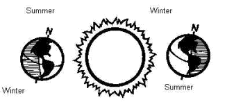
The Four Seasons:
The earth is slightly tilted
on its axis. As the sun shines on the earth, it shines more directly on
the northern hemisphere in June, and more directly on the southern hemisphere
in December. That's why the seasons are different in each
hemisphere. In the spring and fall, the sun shines fairly straight on the
equator, giving both hemispheres equal warming.
Experiment:
Global Lighting:
Take a globe and a light bulb
or flashlight. Imagine the globe is the earth and the light is the
sun. In the summer, what would be the position of the earth? What
is the earth's position in each of the other seasons?
Spring:
You
don’t have to look far to see signs of spring.
From the budding of the trees and the warming of the temperatures to the
animals coming out of their winter hideouts, there seems to be a promise of new
birth and color in the springtime air.
The first day of spring is around
March 20 or 21, depending on what day the vernal equinox occurs. This is when the sun sits directly above the
equator on its apparent trip northward.
Of course this sun isn’t moving; the Earth is. As Earth revolves around the sun, the top half, called the
Northern Hemisphere, becomes tilted more toward the sun as winter turns to
spring. Meanwhile the bottom half, the
Southern Hemisphere, becomes tilted more away from the sun. The beginning of spring for us is the
beginning of autumn for people in Australia and the southern parts of Africa
and South America.
Unequal Equinox:
The word “equinox” comes from Latin
and means “equal nights.” Around March
20, sunrise and sunset are about twelve hours apart everywhere on Earth. Because of that, a lot of people think that
day and night are of equal length on March 20.
But actually the day is a little longer than the night on this
date. There are a few reasons for
that. Sunrise occurs when the top of
the sun (not the center) is on the horizon.
But the sun actually appears to be above the horizon when it is in fact
still below it. That’s because Earth’s
atmosphere refracts or “bends” light coming from the sun, so we see the sun a
couple of minutes before it actually rises over the horizon. If you add the daylight that persists after
sunset, you’ll find the day on the equinox is several minutes longer than the
night.
Variety in Spring Weather:
In the United States, spring is a time of transition not only for
plant and animal life, but for the weather too. It can mean weather extremes from very cold and snowy days to
humid and stormy days. Some of the
country's biggest snowfalls have occurred in March, and the period from March
to May is the time of year when much of the south is most likely to get severe
thunderstorms with hail and even tornadoes.
This is why the beginning of spring is a good time to put together a
plan for what you and your family would do in case of a severe thunderstorm or
tornado.
Summer
Heat:
It's summer and the heat is
on. The summer solstice in the Northern Hemisphere, or top half of Earth,
is around June 21. That's when the sun reaches its most northern point
over our planet. The days around June 20 are the longest of the year, and
the rays from the sun beat almost directly down on use and warm us up.
Longest, Not Hottest:
You might think that the
longest days of the year would be the hottest. But they are not.
The hottest weather, on average, comes about a month after the summer
solstice. This is because the amount of heat from the sun continues to
accumulate during the long hot days, and the short nights don't allow as much
heat to leave. The days start to cool down only after the days grow short
enough to allow more heat to leave Earth's surface than arrives.
Humidity:
It is not the heat, they say, but
the humidity. Humidity is the amount of
moisture in the air. When the air has
so much moisture in it, our bodies don’t do a good job of cooling us down because
sweat doesn’t evaporate as quickly from our skin. That is why we feel so hot on a humid day. In fact, the temperature we feel may be
warmer than the actual air temperature.
This is called the heat index.
Look at the figure below. If the
temperature is 100 degrees and the relative humidity is 50 percent, the heat
index, or the temperature we actually feel, is 120. Hot humid days can be dangerous for humans and animals, so stay
out of the sun and drink lots of water when the humidity is high.
Figure 1 - Heat Index

The Sun Starts It All:
The changes start with the sun and the earth’s orbit around
it. Often people think that our
temperatures get cooler in autumn because the earth moves farther from the
sun. But this is not true. What
actually changes is not the distance of the earth to the sun, but the angle of the sun’s rays on the
earth. In our summer, the sun shines
more directly on the top half of the earth, or northern hemisphere. That’s when we see long warm days. In our winter, the sun shines more directly
on the bottom half of the earth, or southern hemisphere. With less and less direct sunlight on the
top half, the days here get shorter and temperatures get colder as winter
nears. Those shorter days and cooler
temperatures act as a signal to the trees and plants around us to get ready for
winter.
Chlorophyll (The Magic
Chemical):
All summer long, a tree’s leaves have been making food for the
tree so it can grow. An amazing
chemical in the leaves, called chlorophyll,
uses sunlight to turn carbon dioxide and water into the tree’s breakfast, lunch
and dinner. Chlorophyll gives the
leaves their green color. Also in the
leaves are other chemicals with yellow and orange colors—the same chemicals
that give color to some flowers, carrots, and even bananas. You don’t see those colors in summer because
there is so much green chlorophyll in the leaves hiding the other colors.
In the winter, the short days don’t provide enough sunlight for
the trees to make their food, so the trees live off the food they stored during
summer. Before winter arrives, the
shorter days make the trees slow down their food making, and the green
chlorophyll disappears from the leaves.
That’s when the yellow and orange colors take over. At the same time, other chemical changes may
happen in the leaves, forming other colors such as red or purple. Like an artist mixes paint for his canvas,
the chemicals mix to form different colors in different trees. Eventually some trees, but not all, lose
their leaves.
How Bright Can It Get?
You may have noticed that in some years, the leaves seem more
brightly colored than in others. Again,
weather is the reason. The leaves are
brightest when the late summer is warm and dry and autumn has a lot of sunny
days and cool nights with temperatures in the upper thirties or low
forties. The sunny days will help the
leaves make some food, but the cool nights will keep the food from moving out
of the leaves. Under those weather
conditions, the trapped food will form brilliant purple and red chemicals in the leaves.
On the other hand, if the autumn days are cloudy and the nights
are warm, the leaves won’t produce as much trapped food and so they will not be
as colorful. If temperatures go below
freezing at night, the frost will dull the leaves’ colors. Sometimes leaves on the same tree may have
slightly different colors from one another.
That’s because different leaves receive different amounts of sunlight,
so some leaves produce more red and purple chemicals than others. On some trees, leaves that receive a lot of
sunlight may turn red, while the leaves in the shade may be yellow. Again, it is the sun that is responsible for
nature’s wide palette of colors.
Look Around:
As you are playing outside or riding in your car this fall, take a
closer look at the trees around you.
Take a moment to think about the colors you see and how they got
there. And as you observe the changes
in the season and the changes in the weather, you just might be able to
forecast how bright this year’s autumn colors will be!
Winter:
When
we think of winter, we often imagine sledding, icicles and snowball
fights. But think about this: winter is
when earth’s north pole is tilted farther away from the sun than at any other
time of the year. This is called the
winter solstice, and the days just before Christmas are the shortest of
all. During this time, the sun shines
more directly on the lower half of the earth, or Southern Hemisphere. While we in the United States have winter,
Australia, South Africa and the southern parts of South America will have
summer. Because the weather continues to
cool for about another month after the shortest days, the coldest weather actually
arrives after the winter solstice. For most of the Northern Hemisphere, January
and February are typically the coldest months.
What's Up with Winter?
The type of precipitation we
get depends on the temperature inside the clouds and the temperature between
the clouds and the ground. In clouds
that are cold enough for ice crystals to form, we can get snow. Those cold clouds aren’t hard to find. Even in the summer, most of our rain
actually starts out high in the clouds as snow. But in winter, the temperature of the air is sometimes cold
enough all the way from the clouds to the ground, so snowflakes don’t melt into
raindrops. They stay in crystal form
and we see snow pile up and schools close.
Figure 2 - Temperature Rain
Relationship
Look at the figure
above. Sometimes there is a layer of
air in the clouds that is above freezing, or 32 degrees F. Then closer to the ground the air
temperature is once again below freezing.
Snowflakes partially melt in the layer of warmer air, but then freeze
again in the cold air near the ground.
This kind of winter precipitation is called sleet. It bounces when it
hits the ground. If snowflakes
completely melt in the warmer air, but temperatures are below freezing near the
ground, rain may freeze on contact with the ground or the streets. This is called freezing rain, and
significant freezing rain is called an ice storm. Ice storms are extremely dangerous because the layer of ice on
the streets can cause traffic accidents.
Ice can also build up on tree branches and power lines, causing them to
break and our lights to go out.
The Water Cycle:
The rain that falls from the
sky today has been around for thousands of years. The molecules of water
in today's rainfall might have been in yesterday's cloud or last week's dew, or
in a lake or ocean. Although water takes three basic forms (liquid, solid
and gas) we see in many forms of it, such as frost, snow, rain, and clouds.
The cycle of evaporation, condensation, and precipitation never ends.
Triple Waters: Water
comes in three forms. As a liquid, we see it in the lakes and oceans, we
see it falling as rain, and we see it come into our home for drinking or
washing. As a solid, we see water as ice and snow. As a gas, water
vapor is always floating in the air. Water changes from liquid to solid
by freezing. It changes from liquid to gas by evaporation. It
changes from gas to liquid by condensation. Can you guess how it changes
from solid to liquid?
Air Full of Water:
You can't see it, but the air contains a lot of water. Warm
air can hold more water vapor than cold air. When air gets cold, the
water vapor condenses into clouds. And when warm air holds a lot of water
vapor, the air can feel sticky and damp. The amount of water in the air
is called humidity.
Rainbows, Halos and Coronas:
Throughout time, people have
been fascinated with rainbows. Their
arched splashes of color have been the subject of songs and poems, stories and
mythology. In the Bible, the rainbow is
seen as a sign of God's promises, and most of us are familiar with the legend
of the pot of gold at the end of the rainbow.
To unlock the rainbow's secrets, let's explore how water and light work
together to produce a colorful work of art.
What makes rainbows so
mysterious is this simple but often puzzling fact: Rainbows are light. You
can't touch them. You can't reach around behind them. They exist only in the
eyes and sometimes the photographs of the people who see them. Light, or more specifically visible light,
includes every color we can see, with violets and blues on one end of the
spectrum and oranges and reds at the other end. A rainbow is visible light
broken into what we see as seven colors: red, orange, yellow, green, blue,
indigo and violet.
What Does It Take?
Three things must happen for
you to see a rainbow's colors. First,
the sun must be shining. Second, the
sun must be behind you, and third, there must be water drops in the air in
front of you. Sunlight shines into the
water drops, which act as tiny prisms that bend or "refract" the
light and separate it into colors.
Actually, the rays of light
bend twice. As they enter the drops,
the rays of light bend, then reflect off the back of the drops. Then they bend again, this time while
exiting the drops. That's when the
light appears before our eyes. Each drop reflects only one color of light, so there must be many
water drops to make a full rainbow. You'll see the brightest rainbows when the
water drops are large, usually right after a rain shower.
The rainbow is circular
because when a raindrop bends light, the light exits the raindrop at an angle
40 to 42 degrees away from the angle it entered the raindrop. The violets and blues bend at a 40-degree angle, and the oranges
and reds bend at a 42-degree angle. As
a result, the only beams of light you see are from raindrops that are 40 to 42
degrees away from the shadow of your head.
This gives the rainbow its curved appearance.
Full Circle Bows:
In the song "Moon
River," Georgia songwriter Johnny Mercer wrote, "We're after the same
rainbow's end." Actually, though,
rainbows have no end. We usually don't
see the full circle because the horizon of the Earth is in the way. But if the sun is very low in the sky, either just before sunset
or just after sunrise, we can see a half circle. The higher the sun is in the
sky, the less we see of the rainbow. The
only way to see the full circle of a rainbow in the sky is to be above the
raindrops and have the sun behind you. You would have to look down on the drops
from an airplane.
Double the Pleasure:
Often you can see a second
rainbow above a brighter one. This is
caused by extra reflection inside the raindrops. Because the secondary rainbow is formed from two reflections
instead of one, it has a wider radius than the first rainbow and its colors are
reversed, with red on the bottom and indigo on the top.
The secondary rainbow also
isn't as bright as the first because it's a secondary reflection.
A third or a fourth rainbow
also can occur because light can be reflected more than two times within a
raindrop. But we rarely see them
because they are even fainter than a secondary rainbow.
A Few Oddities:
Because rainbows are light
and because light rays strike everyone's eyes a little differently, the rainbow
you see will be a little different from the one someone else sees, even if he
or she is standing right beside you.
Someone else a short distance away or looking from a different angle may
see a much different rainbow -- or no rainbow at all.
Another oddity is that you
might see a rainbow's reflection in a lake without seeing any rainbow above it
in the sky! That's because you may be
at the wrong angle to see the rainbow but are in the perfect spot to see its
reflection in a lake.
How To See A Halo:
As any avid sky watcher
knows, there are many other examples of color in the sky. Have you ever seen a single ring of color
around the sun or moon? It is a halo,
and it occurs more frequently than a rainbow.
To see a halo, don't look directly into the sun. Instead, block the sun
from your view with your hand, a car visor or other object so you can just see
the clouds around it. Sunglasses also may help you see a halo -- but even with
sunglasses, you'll need to block the sun from your eyes.
Sometimes the halo is
white. Sometimes you can see red and
orange in the middle, with yellow and blue at the outer edges. A 22-degree halo is the most common. It is formed when light refracts -- or bends
-- around the edges of long ice crystals at a 22-degree angle. If a thin cloud's ice crystals are in the right position, you
might see arcs just above or below the halo. The arcs form when light refracts
inside long pencil-shaped ice crystals.
Flat ice crystals can produce
an effect high above the halo called a circum-zenithal arc - or an upside-down
rainbow. Also when light refracts through
flat horizontal ice crystals, you might see bright spots of light along the
right and left sides of a halo. These
bright spots are commonly called sun dogs; their scientific name is parhelia.
Coronas:
They are similar to halos but are formed from a cloud's water
drops rather than from ice crystals.
Light, which shines through cloud droplets, curves around the circular
drops and gets diffracted. This means
it spreads out, creating an area of light larger than the sun or moon. This "crown" of milky light around
the sun or moon is the corona. When all
the cloud droplets are about the same size, the diffracted light can make the
corona separate into colors. These
colors may repeat themselves.
Hurricanes:
Summer
also brings hurricanes. From late
spring to early fall, weather conditions come together to form swirling tropical
cyclones over the Atlantic and Pacific oceans.
These develop from areas of low pressure and thunderstorms over the warm
seawater. The thunderstorms give off
heat that warms the atmosphere. Air
rises and the barometric pressure falls even more. As the air pressure drops, winds increase, and a tropical
depression may form. When steady winds
reach 39 miles an hour, the cyclone is called a tropical storm and it gets a name. If winds reach a speed of 74 miles an hour
inside the tropical cyclone, we call it a hurricane. Near the hurricane’s center will be an area with very few clouds
where the air sinks. This is the “eye”
of the hurricane. Most hurricanes never reach the United States
coastline, but those that do can bring high waves, coastal flooding and
destructive winds.
Typhoons vs. Hurricanes:
Typhoons are the same thing
as hurricanes. That is the name used in
the western Pacific Ocean. In the Indian Ocean, they are called tropical
cyclones.
Summary:
The blanket of air around the earth is called
the atmosphere. The sun is the main
reason why we have weather. There is
one basic reason we have weather, and that is the sun. Weather systems start because the sun's
energy heats up some parts of Earth more than others. Most of the time the sun shines most directly on the middle of
Earth, with less heating at the north and south poles. Earth is also unique in that all three forms
of water--liquid, solid and gas--exist naturally. Heating from the sun can also trigger thunderstorms.
Some vapor freezes into tiny ice crystals that attract cooled
water drops. The drops freeze to ice
crystals, forming larger crystals we call snowflakes. When the snowflakes meet warmer air on the way down, they melt
into raindrops. Snowflakes partially
melt in the layer of warmer air, but then freeze again in the cold air near the
ground. This kind of precipitation is
called sleet. Cumulonimbus clouds may
tower more than 50,000 feet and cover from just a few square miles up to two
hundred square miles. Depending on wind
direction and temperature, you may hear thunder for up to fifteen or twenty
miles. Most clouds have two parts to
their name. Usually the first part of
the name has to do with the height and the second part refers to the
appearance. Snowflakes form when water
vapor freezes into ice crystals in cold clouds. The colder the temperature is, the smaller the crystals.
The sun causes all our weather because it heats the earth
unevenly. The contrast between the hot
parts and the cold parts of the earth turns our atmosphere into a powerful
engine. As the sun warms up the earth,
the ground absorbs the heat, and reflects some of it back into the air. Although wind blows from areas of high
pressure to areas of low pressure, it doesn't blow in a straight line. That's because the earth is rotating. The Beaufort Scale is used to estimate wind
speed. The Beaufort Scale is a system of
recording wind velocity (speed) devised in 1806 by Francis Beaufort
(1774–1857). It is a numerical scale
ranging from 0 for calm to 12 for a hurricane.
As the sun shines on the earth, it shines more directly on the
northern hemisphere in June, and more directly on the southern hemisphere in
December. That's why the seasons are
different in each hemisphere. In the spring and fall, the sun shines
fairly straight on the equator, giving both hemispheres equal warming. Around March 20, sunrise and sunset are
about twelve hours apart everywhere on Earth.
Some of the country's biggest snowfalls have occurred in March, and the
period from March to May is the time of year when much of the south is most
likely to get severe thunderstorms with hail and even tornadoes.
The summer solstice in the Northern Hemisphere, or top half of
Earth, is around June 21. June 20 is the longest of the year. Hot humid days can be dangerous for humans
and animals, so stay out of the sun and drink lots of water when the humidity
is high. What actually changes the temperature
is not the distance of the earth to the sun, but the angle of the sun’s rays on
the earth.
Chlorophyll, uses sunlight to turn carbon dioxide and water into
the tree’s breakfast, lunch and dinner.
Chlorophyll gives the leaves their green color. The leaves are brightest
when the late summer is warm and dry.
During the winter we see some rain, but sometimes we see other forms of
precipitation too. Winter precipitation
also includes snow, sleet, and freezing rain.
The type of precipitation we get depends on the temperature inside the
clouds and the temperature between the clouds and the ground.
In the Bible, the rainbow is seen as a sign of God's promises, and
most of us are familiar with the legend of the pot of gold at the end of the
rainbow. The rainbow is circular
because when a raindrop bends light, the light exits the raindrop at an angle
40 to 42 degrees away from the angle it entered the raindrop.
The violets and blues bend at a 40-degree angle, and the oranges
and reds bend at a 42-degree angle.
Sometimes the halo is white.
Sometimes you can see red and orange in the middle, with yellow and blue
at the outer edges. A 22-degree halo is
the most common. Coronas are similar to halos but are formed from a cloud's
water drops rather than from ice crystals.
When steady winds reach 39 miles an hour, the cyclone is called a
tropical storm and it gets a name. If
winds reach a speed of 74 miles an hour inside the tropical cyclone, we call it
a hurricane. Typhoons are the same
thing as hurricanes. That is the name
used in the western Pacific Ocean. In
the Indian Ocean, they are called tropical cyclones.
Bibliography
Introduction to Meteorology (Atm. Sci. 240). Instructor: Professor
Jon Kahl. Course Information. General Information · Syllabus ... www.uwm.edu/~kahl/240/.
"Introduction to Meteorology and Related
Sciences," web site: www.msc_smc.ec.gc.ca/education/imres/index_e.cfm.
The navigation men, this module is called "Meteorology"
and the available modules are listed as menu items, beginning with this
introduction. ...
ww2010.atmos.uiuc.edu/(Gh)/guides/mtr/home.rxml.
Note 1: Coriolis Effects
Report by Dr. Francisco J. Collazo, web site: www.fjcollazo.com.